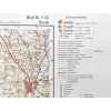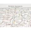
Original-style Deutsche Heereskarte military maps, produced and used by the German army during World War II. Issued from 1939 onward, these maps provided essential terrain information for operations across Eastern and Central Europe. Their 1:100,000 scale offered a balance between detailed topography and field practicality.
Used by commanders, reconnaissance units, and infantry alike, these maps included standardized symbols (railways, forests, bridges, churches, elevation marks), along with technical data such as magnetic deviation and elevation profiles.
Variants:
- Kursk (1941) – shows the terrain leading to Kursk, crucial in planning Operation Citadel. The Battle of Kursk, which began on July 5, 1943, was a decisive clash on the Eastern Front.
- Minsk (1941) – covers the area south of Minsk, key to the encirclement maneuvers during the Battle of Białystok. The offensive enabled a swift Wehrmacht advance to Smolensk.
- Žilina (1939) – from the early war period after German troops entered Slovak territory. Used during unit movements toward northeastern Carpathians.
- Trnava (Tyrnau, 1944) – German-designated map sheet, used during the final stages of the war for organizing fallback positions and retreats into Austria.
A perfect item for reenactment map kits, staff displays, command post dioramas, museum settings, or as a collectible with strong historical value.
| Category: | Desk items |
|---|---|
| EAN: | Choose variant |
| ? Dimensions (Kursk):: | 500x650mm |
| ? Dimensions (Minsk):: | 500x650mm |
| ? Dimensions (Žilina):: | 500x650mm |


